


Cities
08.10.19
Buenos Aires
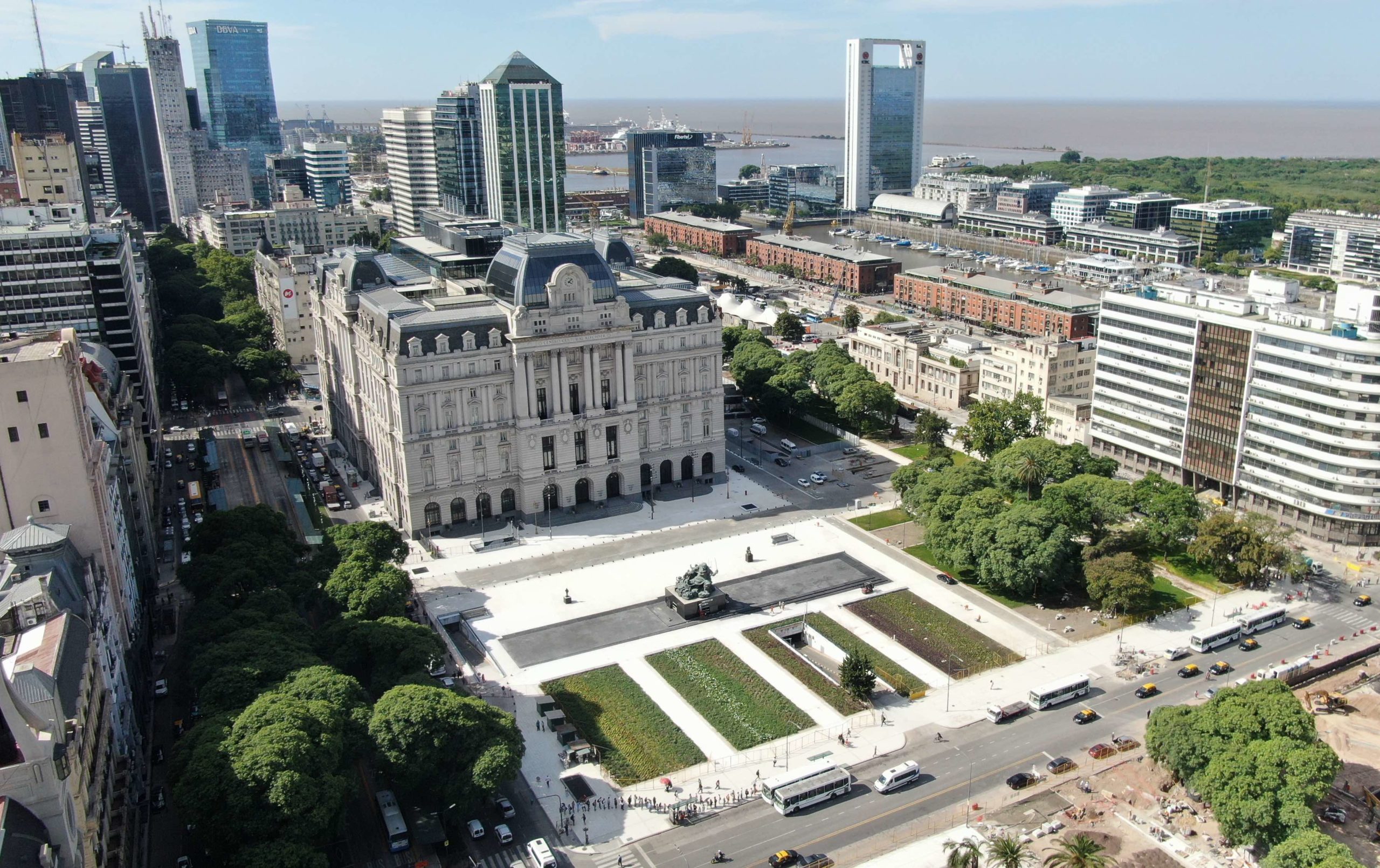
A large urban transformation has completely changed the dynamics of a vital area of the city of Buenos Aires.
New cultural Center and new Plazas
Billboard
Skyscrapper
Halfpage
The City of Buenos Aires recently incorporated a 20 hectare-system of pedestrian green spaces which complete the project of a new urban highway connecting north and south ends in the most central area.
Buenos Aires is the largest city in Argentina and the second largest city in Latin America, with a total area of 200 square kilometers and almost 3 million city residents (and 13.5 million residents in the metropolitan area). Originally built on the western shores of the Río de La Plata (a river which stretches 220 kilometers and empties into the Atlantic Ocean), Buenos Aires has expanded by claiming land from the river and by concentrating urban growth in the extensive plains located to the south, west and north of the original settlements and port.
Most iconic districts with fragmented road network
The central area, which includes the country’s most important institutional, financial and cultural buildings, such as the Pink House (the official workplace of the president of Argentina), is adjacent to Madero Port (Puerto Madero), an area of 170 hectares that was fully developed during the 1990s. This piece of land, adjacent to the river and a 350 hectare ecological preserve, was subject to a large-scale urban transformation process, which renovated the non-operational first port of the city and the surrounding abandoned areas. Nearly thirty years later, Puerto Madero has become one of the most extensive, most visited and most iconic districts of Buenos Aires. However, the problem of the insufficient connection to the central area and the rest of the city was never solved and became worse over time: the disconnection was due not only to pedestrian dynamics between Puerto Madero and the central area in the west, right across two major, intensively used avenues, but also to the city’s north-south orientation, fragmenting the road network and increasing the problem of vehicle traffic and congested streets.
Below-grade highway
In 2016, the National Government requested funds (a loan covering 60% of the costs) from the Development Bank of Latin America and in 2017, operations commenced on the redesign and construction of a new highway to connect the north and south ends of the city’s central area. Today, a new subterranean highway runs for seven kilometers along the western border of Puerto Madero. Its four lanes are restricted to trucks and long-distance buses, generating a vehicle-only avenue at ground-level, as well as a new 10 hectare system for pedestrian connection, promenades, plazas and green spaces in the central area.
With the objective of creating a consistent, contemporary layout for these new public spaces, Madero Port Corporation (Corporación Puerto Madero: a public-private partnership created in 1989 for the port area’s urbanization) carried out in-depth research and elaborate conceptual planning, which formed the basis of a national call for designs. In 2017, the City Government, the Madero Port Corporation and the Central Society of Architects (Sociedad Central de Arquitectos) launched a national call for the redesign of the above named areas as well as the linear park bordering the new underground highway, amounting to a total of 20 hectares of new green spaces.
New urban situations
Before the launch of this competition, all institutions involved had to follow many processes and take important decisions. With regard to land conversion, a new law passed by the City Legislature in 2017 determined to change the originally envisaged land use from urban renovation area to park area. Moreover, the Ministry of Urban Planning worked on the geometric redesign of specific streets and physical aspects of the central area, the most crucial one being the reconfiguration of the curve bordering the gardens of the Pink House, which allowed for the creation of a large, pedestrian-only promenade connecting the north and south ends.
The geometric redesign of this very significant space in the city also required the relocation of some historic monuments of remarkable importance. The most notable relocation was certainly that of the Monumento a Juana Azurduy; located in the gardens of the Pink House since 2015, 9 meters tall and weighing up to 25 tons, this huge bronze sculpture is now resting on a 3-meter-high pedestal, situated in a newly-built plaza in front of a historical, recently renovated culture center. Standing alone, this beautiful statue of the female warrior can now be fully appreciated by people walking by.
These kinds of new urban situations, which come along with the creation of the new highway and its adjacent spaces, resulted from the ideas of the winning team of the competition mentioned earlier.
Buenos Aires: Belvedere-style vista
The team visualized a series of novel key spaces which seek to 1) reinforce the pedestrian connection between the city’s central area, Puerto Madero and the riverfront (west-east direction) and, in turn, 2) implement a system of green spaces extending along the new highway (north-south direction), establishing a linear park for recreational and tourist purposes.
The most attractive idea of the team’s proposal, or at least the one that has been realized most successfully , which is embraced by locals in their everyday lives, was the incorporation of a 60-meter-wide staircase that negotiates the existing elevation changes between the two affected areas of the city. Positioned right at the intersection of the west-east axis of the Pink House and the north-south axis of Puerto Madero and the new highway, this large staircase and elevated promenade not only offers a natural connection for pedestrians, but also a fantastic, belvedere-style vista, opening up views of the docks, the marinas and the distant skyscrapers. The large stairs are also lined up with the Woman’s Bridge (Puente de la Mujer), an iconic footbridge with sleek and elegantly curved lines, designed by the internationally famous architect Santiago Calatrava (2001).


Connecting spaces and generating pedestrian-friendly designs
This very large urban transformation, the first stages of which have just been completed, with the final stages scheduled for completion at the end of this year, has completely changed the dynamics of a vital area of the city. The acceptance of these big changes by the local population and the tourists’ fascination when walking around the new areas underline how necessary this project was, connecting spaces and generating pedestrian-friendly, green designs in this central area of the city. The integration of large-scale planted areas only featuring indigenous species, the preservation of existing large trees (a local landmark in Buenos Aires) and the construction of new underground bus parking spaces, which appear as small plazas and green spaces at ground level, are all separate additions, constituting one large integrative landscape plan.
Today, the totality of all the new and renovated pieces provides an institutional, graceful and symbolic setting for the governmental structures, museums and monuments in the central area and a fresh, inviting design for the physical connection with Puerto Madero and the linear park through the new highway. Still under construction, this linear park will cover three kilometers along the recently completed arterial road.
In a city that is constantly resisting economic crisis, in a country where economic instability has become, paradoxically, the most stable situation, physical transformation becomes a sign of hope. Buenos Aires continues to be strong and beautiful, just like the South American heroine Juana Azurduy.
_
Location: City of Buenos Aires, Argentina
Date of completion: First stage: August 2019
Area of the project: 20 hectares / finished: 10 hectares
National competition’s first prize and project’s consultants: Daniel Becker, Sergio Cavalli, Agustín Olivieri, Joan Marantz.
Previous research and conceptual planning: Corporación Puerto Madero, Project Managers: Marcela Suarez, Eduardo Albanese.
Project planning and construction: Ministry of Transport and Urban Development (Minister F. Moccia) / Subsecretary of Planning: SS Carlos Colombo, Director: Guillermo Raddavero / Subsecretary of Projects: SS Álvaro García Resta, Director: Martin Torrado / Subsecretary of Site Works: SS Marcelo Palacio, Director: Gabriel Rosales, Site’s Coordinator: Gustavo Ojeda Ton
Project documentation and detail design: General Direction of Architecture: R.Szraiber, N.Pinto Da Mota, S.Pietragalli, H.Sanchez, B.Belascoain, M.Menéndez, M.Cohen /
Landscape Designers: G.Raffo, V.Nerome.
Photos provided by: City Government of Buenos Aires, Ministry of Urban Design and Transportation / Puerto Madero Corporation.
Skyscrapper
Halfpage
Billboard
Other Articles you may like


